- Catalog No. —
- OrHi 105351
- Date —
- 1901
- Era —
- 1881-1920 (Industrialization and Progressive Reform)
- Themes —
- Geography and Places
- Credits —
- Oregon Historical Society
- Regions —
- Portland Metropolitan
- Author —
- J. Thorburn Ross
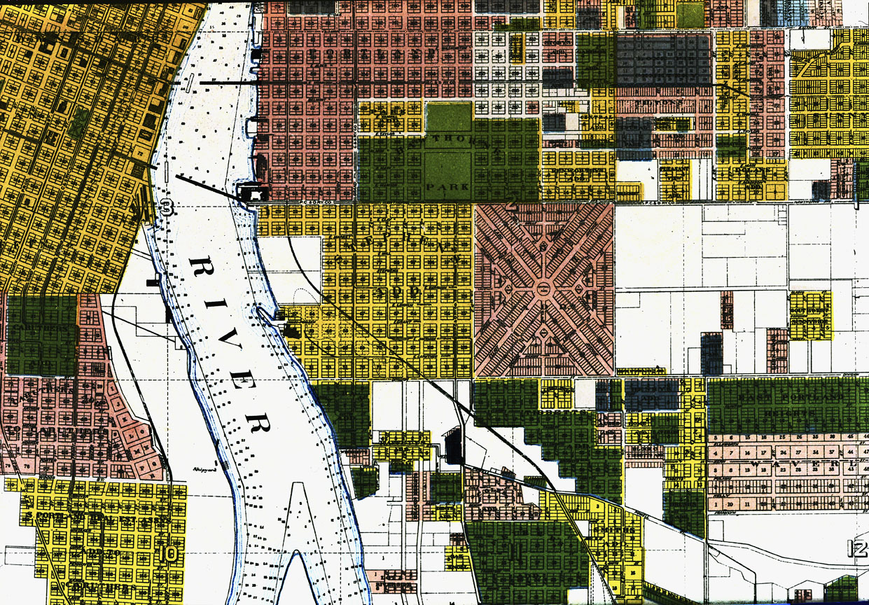
Portland, 1901
This is a small portion of a 1901 real estate map of Portland, showing a section on the east side of the Willamette River south of downtown. The map clearly depicts the way that the land—which twenty years earlier had been farmland with numerous sloughs and springs—was being carved into streets, city blocks, and individual building lots. This was done by numerous individual landowners and developers, and as the map suggests, there were no particular standards to guide the subdivision of land. Most subdivisions are aligned to a north-south grid, but the downtown grid is oriented to the riverbank, and a major subdivision, Ladd’s Addition, is based on two crossed diagonal axes. Streets in one subdivision do not always link smoothly with adjoining plats, and lots sizes vary in dimensions and in overall area—although the 50x100 foot lot dominates this landscape. There were no zoning laws at this time, so industries and residences often mixed in the same neighborhood. Industry tended to develop along the riverbank and the railroad tracks; most of the remaining lots became residential properties, with retail development along streetcar lines and major roads.
At the top left of the map is the Madison or Hawthorne bridge, built in 1888 as a private toll bridge. Streetcar lines crossed this bridge from its opening, which stimulated the real estate development in southeast Portland and the creation of subdivisions from farmland. The streetcars—powered in 1901 by electricity—extend east on Hawthorne and north and south along Grand and 11th avenues. Two east-west streets, Hawthorne and Division, which bound Ladd’s Addition, follow major survey lines (a fact that gave Division Street its name). Ladd’s Addition was platted in 1890, but at the time this map was published, the lots had not been sold; like the unplatted land immediately to the east, this land was still essentially rural.
The Southern Pacific Company railroad tracks, heading south for California, cross the map diagonally from top left to bottom right. The tracks curve from the river shoreline along the edge of what was once an extensive slough that stretched south to the vicinity of Powell Valley Road (now Powell Boulevard); the unplatted lands along the tracks reflect its inappropriateness for subdivision. However, real estate agents being perennially optimistic, many lots were platted in areas that were far from being practical or suitable building sites.
The map’s publisher, J. Thornburn Ross, was a real estate agent who actively developed several streetcar suburbs in southeast Portland beginning about 1889, including Woodstock. He is the namesake of SE Thorburn Street and SE Ross Street.
Further Reading:
Snyder, Eugene E. Portland Names and Neighborhoods: Their Historic Origins. Portland, Oreg., 1979.
Written by Richard Engeman, © Oregon Historical Society, 2005.