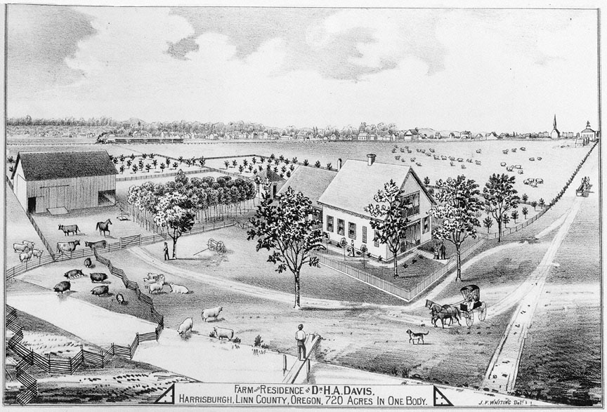
This image of an 1878 engraving found in Historical Atlas Map of Marion and Linn Counties, Oregon shows the property of Dr. Henry A. Davis of Harrisburg in Linn County. Davis was a physician who, with his wife, Hester, came to Oregon by wagon train in 1852 and settled in Linn County in 1853. The Atlas lists his occupation as a farmer and a stock grower.
Between the implementation of the Donation Land Law in 1850 and the publishing of the Historical Atlas Map of Marion and Linn Counties, Oregon, the Willamette Valley underwent a profound transformation. By the time the Donation Land Law expired in 1855, a total of 5,289 donation land claims were filed with the Surveyor General’s office in Oregon City. (An additional 2,141 claims were filed in Roseburg; 5 were filed in The Dalles, and 2 more claims were made in La Grande). The Homestead Act of 1862 continued to guarantee later arrivals to Oregon a quarter section of land (160 acres) if they improved their claim and could prove they had occupied it for five years. Between the two land acts, the Willamette Valley became a conjoined patchwork of large and small parcels with little free room to spare.
For immigrants who had the means to do so, land could also be purchased outright rather than claimed through a grant process. This is how Dr. H. A. Davis, a physician who lived outside of Harrisburg on the Willamette River, chose to accumulate his property. In addition to filing for an original donation land claim for 640 acres for himself and his wife, Davis also purchased 630 acres in 1865 from William A. Forgey, a substantial landholder in the vicinity of Harrisburg. The Atlas also shows that Davis owned other large parcels of land in the vicinity of Harrisburg, one that totaled 620 acres and another of 480 acres.
It comes as no surprise that the Davis farm is included in the Historical Atlas, given his status as a prominent landowner. The stylized illustrations in the book show only well developed farms, as well as some industrial sites such as a sawmill. In addition to the illustrations of individual properties, the Atlas contains detailed maps of both Marion and Linn Counties, an overview of Oregon history, community profiles, and business summaries. The introduction, which claims that the work is the “first of its kind in the state of Oregon,” hopes that the residents “might feel a just pride in showing it to the many persons who yearly visit the Willamette Valley in search of health, pleasure, and profit.” In some respects, the contents might be interpreted as a more elaborate form of a promotional pamphlet, touting the benefits of life in the valley and presenting nothing but wealth and success.
Further Reading:
Historical Atlas Map of Marion and Linn Counties, Oregon. San Francisco, Calif., 1878.
Tweedt, Bess. Historic Harrisburg: A Little Town on the Willamette River. Eugene, Oreg., 1994.
Wheeler, L.M. History of Linn County Oregon. Portland, Oreg. 1982.
Written by Dane Bevan