These three maps show the loss of Indian homelands in Oregon from 1841 to 1880. Although these maps offer a visual representation of Indian lands, they are only approximations of homeland boundaries. When viewing historical maps, it is important to remember that most were created by white cartographers who imposed their western political understandings of property ownership on geography and resources. Native people most often practiced communal land management and resource sharing, where boundaries were fluid and shifted during seasonal subsistence practices and with political alliances and warfare.
OHS has added color to these maps to make the boundaries clearer to modern viewers.
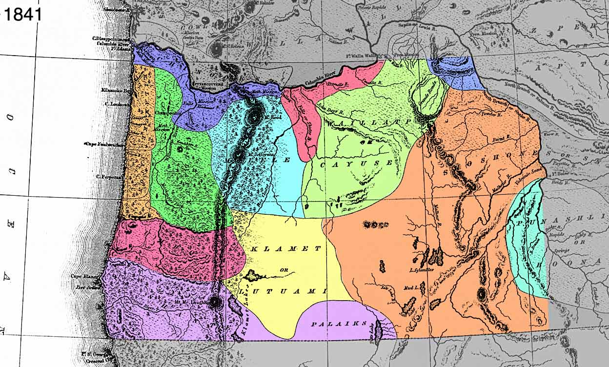 |
Map #1 - Oregon Territory Created by the U.S. Exploring Expedition, 1841. OrHi 986847Members of the United States Exploring Expedition, led by Lt. Charles Wilkes, created this map in 1841 during a four-year government funded mission to explore the geographic region known as the Oregon Country. By 1841 Indians in the western portion of the Oregon Country had suffered substantial population loss from diseases imported by Euro-Americans throughout the late 18th and 19th centuries. Why do you think the mapmakers included Indian tribal locations on the map? Between 1850 and 1855 census records indicate that 25,000 to 30,000 emigrants entered the Oregon Territory. The newcomers lobbied the government to remove Indians from their homelands so that they could inhabit and establish farms in the Willamette Valley. In 1850 Congress passed the Oregon Indian Act which gave the President authority to appoint a Board of Commissioners to negotiate treaties with the Indians and extinguish their title to tribal lands. |
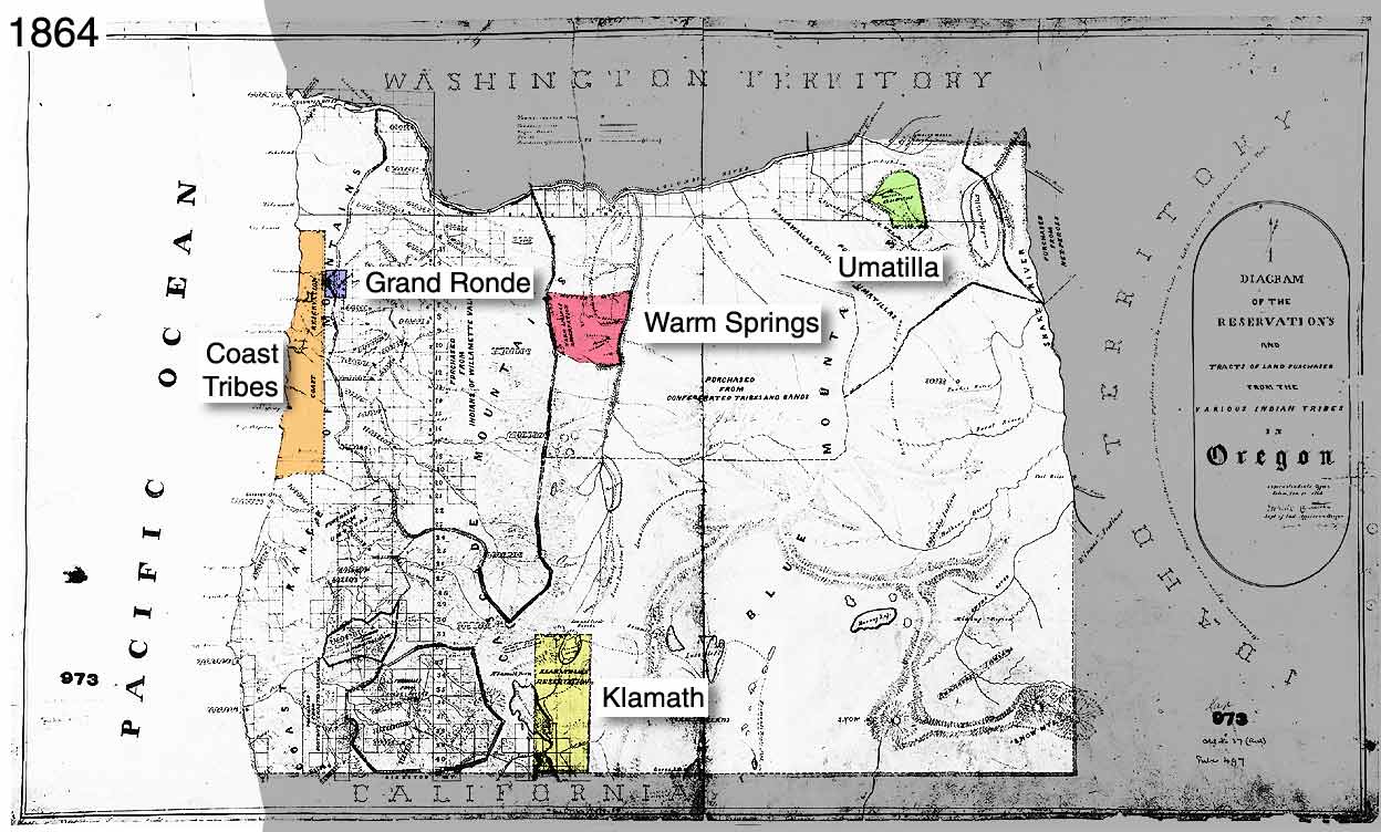 |
Map #2 - Diagram of the Reservations and Tracts of Land Purchased from the various Indian Tribes, 1864. CN085680The second map shows original lands purchased from the Indians and the remaining reservations, which include the Umatilla, Warm Springs, Siletz, Grand Ronde, and the Klamath. Between 1853 and 1864, Oregon's Indian populations were gradually relocated to permanent reservations. Indians often agreed to treaties with governmental representatives because they believed it was the only way to retain land and the rights to hunt, fish, and gather food at usual and accustomed places. Some Indians received payments for their land (usually a nominal fee of less than a dollar per acre) and many eventually moved to the reservations, where their land base quickly diminished. Why do you think reservations were established in the locations represented on this map? Are the reservations close to mountains, rivers, and towns, townships (designated by square boxes) or other prominent physical landscapes? |
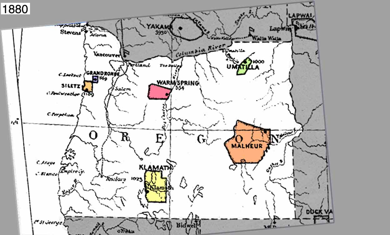 |
Map #3 - Map Showing Indian Reservations in the United States West of the 84th Meridian and Number of Indians belong thereto, 1880. Mss 442By 1880 Oregon had six Indian reservations. The Malheur Reservation, located in the Harney Basin, was created in 1872 to contain numerous Paiute bands. White ranchers wanted the rich meadowlands for stock raising and the federal government placed the 1,778,580-acre reservation back into the public domain by 1883. In 1865 and 1875, the federal government opened the southern and northern portions of the Siletz Reservation to white settlement. All other Oregon reservations experienced a similar fate in 1887 with the passage of the Dawes Severalty or (General Allotment) Act). Congress passed the Severalty or General Allotment Act in 1887. The Dawes Act allotted 160-acre plots of land to Indian individuals or heads of families who resided on reservations. This land was held in trust by the federal government for 25 years. White settlers were allowed to purchase remaining reservation land and as a result the Indian land base quickly diminished in size. U.S. government policy makers hoped the Dawes Act would encourage Indians to take up farming and assimilate smoothly into Euro-American society. However, Indian allotments were often unsuitable for farming and Indians lacked the proper training or tools to produce successful farms. |