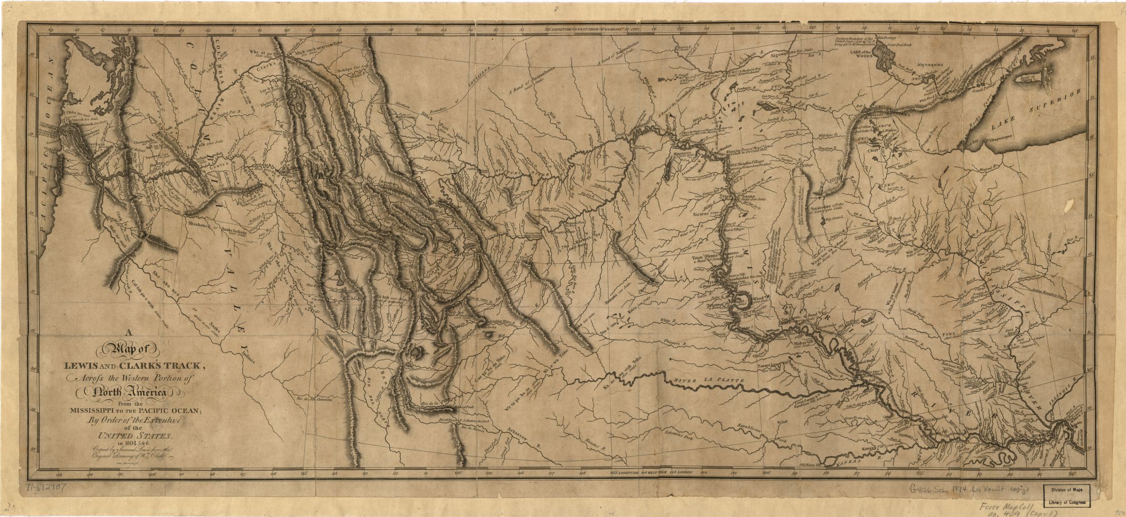
This map, titled A Map of Lewis and Clark's Track across the Western Portion of North America from the Mississippi to the Pacific Ocean, published in 1814, is based on William Clark’s cartography from the 1804–1806 Expedition and information from fur trappers and other explorers in the American West after 1807. Geographer John Allen has called the map “an item of superlative craftsmanship and analysis.” In addition to new cartographic information, the map also marks the end of the search for a Northwest Passage, a fabled waterway that many Americans and Europeans hoped would provide an easy passage from the Atlantic to the Pacific.
At the beginning of the nineteenth century, it was generally thought that the headwaters of the Missouri River were in close proximity to the headwaters of the Columbia River and that only a plateau or a gentle “pyramidal height-of-land” separated the two systems. Clark and Meriwether Lewis proved this theory wrong when they found that a series of rugged mountain ranges divided the continent. Moreover, the rivers descending the western slope of the Rocky Mountains proved to be unnavigable.
Clark’s map was copied for engraving and printing by Philadelphia cartographer Samuel Lewis. It was one of the most important maps created during the nineteenth century, and was the foundation upon which the next generation of American cartographers built their knowledge of western geography.
OHS has a copy, but it is best viewed on the Library of Congress digital site, here.
Written by Kathy Tucker and Cain Allen, 2002, 2004; revised 2021
Further Reading:
Allen, John Logan. Passage through the Garden: Lewis and Clark and the Image of the American Northwest. Urbana: University of Illinois Press, 1975.
Lewis, Meriwether, and William Clark. The Journals of the Lewis and Clark Expedition. Vol. 1, Atlas of the Lewis and Clark Expedition, edited by Gary E. Moulton. Lincoln: University of Nebraska Press, 1983.