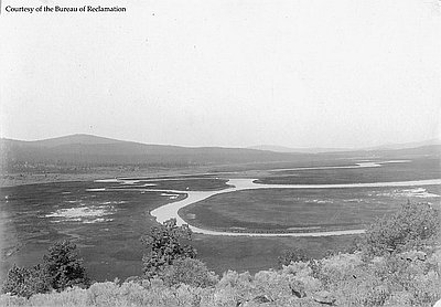
The craggy, wind-blown summit of Steens Mountain—which, at 9,670 feet above sea level, is the highest point in southeastern Oregon—offers a view that extends five thousand near-vertical feet down the face of the escarpment to the alkali basin of Alvord Desert, stretching scores of miles toward the horizon in Idaho. To the west, down the gentler, juniper-studded west side of the mountain, the sheer walls of deeply gouged canyons such as Kiger Gorge and Blitzen Gorge reveal the mountain’s many layers of volcanic rock. Farther to the west, beyond the base of the mountain, is the flat expanse of Catlow Valley, which is the surface of an ancient lakebed. Ten thousand years ago, Lake Catlow held an immense amount of water, and people lived along its shore.
Geologically, southeastern Oregon consists almost entirely of layers of volcanic rock, much of it dark-colored basalt. The region forms part of a 30-to-5-million-year-old volcanic terrain that stretches from the Cascade Range, east across southern Idaho, and nearly to the foot of the Teton Mountains.
Southeastern Oregon also makes up portions of two large geographic/hydrological units: the northernmost section of the Great Basin—southeastern Deschutes County and most of Lake and Harney Counties—and to the east a part of the Snake River Plain, called the Owyhee Uplands—including most of Malheur Count,. Within the entire Great Basin—which also includes almost all of Nevada, most of western Utah, and much of southeastern California—no rivers drain to the ocean; instead, it is a region of interior drainage, where water flows into shallow lakes with no outlet or sinks into the desert floor. The Owyhee Uplands of Malheur County, in contrast, form the broken western edge of southern Idaho’s great Snake River Plain, where the waters of the Snake and tributaries like the Owyhee and the Malheur Rivers join the Columbia and ultimately flow into the Pacific.
Most of southeastern Oregon’s volcanic formations date from between 30 and 10 million years ago. Between 5 and 2 million years ago, massive geologic faulting created a landscape of steep-sided and generally north/south-oriented linear fault-block mountains like Steens Mountain, Hart Mountain, the Warner Mountains, and Abert Rim. The intervening downthrust troughs that formed along fault lines between the upthrust mountains include Alvord Basin, Catlow Valley, and Warner Valley.
During the past 2 million years or earlier, the global Ice Age brought a somewhat cooler and more moist climate, which produced deep lakes in the Great Basin and created large glaciers—like those that carved Kiger and Blitzen Gorges. The climate also created grasslands that supported herds of animals such as wooly mammoths and giant bison.
© Jeff LaLande, 2005. Updated and revised by OHP staff, 2014.