The period from 10,500 to 200 years ago covers the bulk of prehistory of western North America. It is known as the Archaic period of the Holocene. Human activity during the Archaic Period was characterized by the gradual development of localized economies reliant on a wide range of plants and animals. Population densities increased during the Archaic, with the refinement of storage capabilities and intensification of harvests. The bulk of the archaeological sites in central Oregon date from this period.
For example, sites in the Fort Rock Basin date as far back as 11,500 BP (before the present). These could be assigned to the earlier Paleo-Indian period, but they are more indicative of early to middle Archaic lifeways. Other early Holocene occupations also reflect Archaic period lifeways, such as the Newberry Volcano upland occupations, dated to at least 10,500 BP, and the Cascade uplands surrounding Odell Lake, dated to 9500 BP.
What was the environment like during this early Holocene period? A pollen core sample taken from Sunset Cove at Odell Lake indicates a preponderance of grass and juniper pollens, a much different vegetative pattern from the current conifer-dominated plant communities. This may reflect a subalpine, scrub-dominated landscape, which was present while soils were gradually developing in the glacial till and moraines, and laying the groundwork for successive plant communities of greater ecological diversity.
For convenience, we can take the eruption of Mt. Mazama about 7700 BP as marking the end of the early Archaic period. The eruption seriously impacted the central Oregon ecosystems to the point of rendering many of them uninhabitable by humans for centuries. Gradually, however, many plant communities reestablished themselves after the eruption. In other areas, new plant species, which were better adapted to the ash and pumice-derived soils from Mazama’s eruption, predominated.
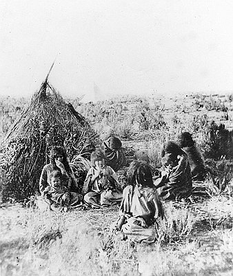
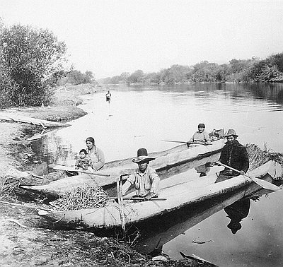
In the middle Archaic period, from 7000–2000 BP, people in central Oregon, like those elsewhere in North America, lived by foraging and collecting seasonally available foods. They hunted wild game, such as deer, antelope and bighorn sheep, smaller mammals such as rabbits, and various species of birds. They established fishing stations adjacent to productive fisheries in salmon streams and the Klamath lakes. Shellfish, such as freshwater mussels, also augmented their diet.
While these game foods were important, wild plants provided the necessary calories to sustain larger populations and allow for some semi-sedentary settlements. Plants could be harvested in great numbers and processed efficiently with hand-made implements. Plant foods stored well after they had been pounded, dried, and made into cakes and biscuits. The increased reliance on plant foods is more pronounced in the northern portions of the central Oregon region, along the tributaries and main stems of the Crooked, Deschutes and John Day rivers. This was perhaps due to lower elevations, milder winters, and access to rocky soils favoring the production of nutritious and desirable roots, such as lomatiums, bitterroot, and camas.
Sites from the middle Archaic period in northern central Oregon show evidence of plant foods and semi-sedentary settlements. Evidence of this pattern includes pit houses, ground-stone artifacts, storage pits, and the like. The more southern parts of central Oregon in Deschutes and northern Klamath Country were likely more productive for wild game and less productive for plant foods. Middle Archaic period sites in this upper Deschutes River region tend to lack pit house features, but they have revealed stone tools along with other stone fragments and flakes related to tool making. These sites may represent camps and temporary-use areas. Occasionally these sites are also associated with ground-stone implements, and other features, such as storage pits, that might indicate other diverse uses.
The late Archaic, dating from 2000 BP to the period of contact between Native Americans and Euro Americans (about 200 BP) appears to be less marked than the middle Archaic in terms of dramatic changes in settlement and subsistence. In eastern portions of central Oregon a population decline seems to have occurred during this time. However, some central Oregon localities with specific resources available may have allowed increased intensification of subsistence and settlement. Big Summit Prairie, in the Ochoco Mountains, is productive for lomatiums and camas, and contains late Archaic pit house sites. Davis Lake in northern Klamath County offered plant food in the form of giant pond lily seeds (wocas). There are several sites at Davis Lake, some with pit house depressions, ground-stone implements, and dugout canoes.
Many late Archaic period sites in central Oregon reflect only transitory use and the creation and maintenance of stone tools, such as sites near the springs of Fall River, south of Bend. There is also some evidence of population movements at this time, resulting in increased population density along the Columbia River, perhaps caused in part by movements of newcomers to the central Oregon region, like the Numic-speaking Northern Paiute.
This period also most likely witnessed the emergence of the familiar Native American groups inhabiting parts of central Oregon up to the nineteenth century. Among these were the Molala, Klamath, Modoc, Northern Paiute, and the Sahaptin-speaking peoples of the mid-Columbia region such as the Tenino and Tygh. The nature of interactions between these groups is not well documented in the archaeological record. Sometime during the middle Archaic, the well-worn “Klamath Trail” was likely established, connecting the Klamath Marsh and the Deschutes River Basin to the Columbia River and the great trading center that developed near The Dalles. This trail followed the Little Deschutes and Deschutes rivers to the Bend area, then passed through Tumalo (a Klamath word meaning “wild plum”) to the Metolius Basin, then back again to the main stem of the Deschutes River and onward to the Columbia.
Anthropologists Beatrice Blythe and Robert J. Suphan identify the Bend area as the homeland of the Juniper-Deer-Eater Band (Hunipui) of the Northern Paiute, thus implying that residential camps were once located in the Bend area. No doubt other groups still utilized the area, passing through to favored game, food collecting, and tool-stone quarry sites. These many residential camps, trails, and short-term use sites dotted the landscape and no doubt aided in the eventual Euro-American settlement of central Oregon. It is also possible that other cultural practices, such as using fire to manage habitats, helped create or at least maintain the open forest conditions, upland meadows, and grasslands encountered by Euro-American explorers and settlers in the nineteenth century.
© Ward Tonsfeldt and Paul G. Claeyssens, 2004. Updated and revised by OHP staff, 2014